
The local communities remain trapped between the interplay of the past developmental lag of the region and the current development impetus

‘Pickled’ infrastructure and connectivity in Northeast India
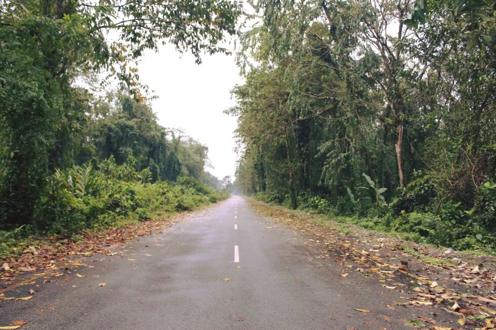
The distant rumblings of a raging thunderstorm in this far-eastern corner of Arunachal Pradesh, nestled in the Eastern Himalayas, were drawing to a close by early morning. As we were driving from Tezu, the headquarters of the Lohit district, making our way to Roing, the headquarters of the Lower Dibang Valley district, the ravages of the storm from the earlier night was evident. The wide, freshly minted road through the undulating forests was covered in layers of fallen leaves and broken branches of trees, almost making a beautiful carpet. This was a new road alignment cut through the forests, a harbinger of connectivity between the two district capitals, built under the Trans-Arunachal Highway project, envisioned by planners of the central government in New Delhi to provide internal connectivity in Arunachal Pradesh, various parts of which were for decades connected by an arterial network of roads crisscrossing through Assam.
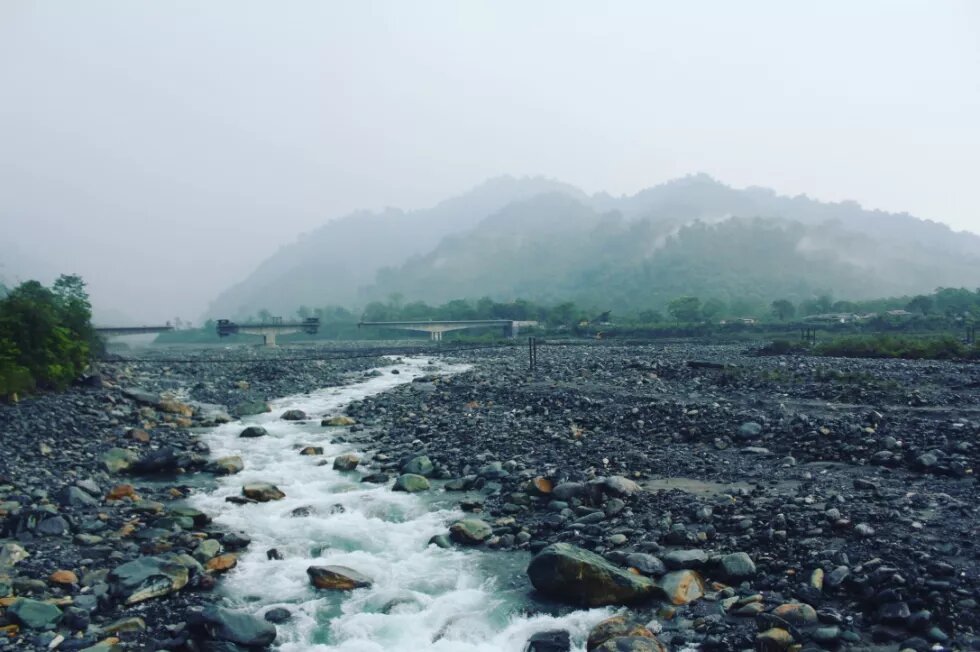
It was still weeks to go before the monsoon of 2016, and after driving for 40 minutes from Tezu, we had to stop at the yet-unfinished bridge over the Diffo river. While assessing if we could take our vehicle through the temporary arrangement underneath the bridge – a platform thrown together from metal and wood over the main channel of the river – two young men arrived on their car. The water level had risen considerably from the rains last night, and there were now multiple channels of the river, which had to be crossed under the unfinished bridge, apart from the main channel. The men were from Roing, both from the Idu-Mishmi community, travelling back from Tezu after attending a marriage. After a quick assessment of the river water, they decided to return and take the old road through Sadiya in Assam, advising us to follow the same.
It was only about 30 minutes’ drive from across the bridge to Roing, but now we had to make a turn, drive back almost all the way to Tezu, take a narrow rickety state public works department (PWD) maintained road through to Sadiya, cross an inter-province border check-gate to enter Assam, drive for about 40 minutes in Assam, and cross another inter-province border check-gate to enter Arunachal Pradesh, and then finally reach Roing after about three hours in total. We caught up again with the two young men at a tea stall on the way, and struck up a conversation. One of them emphatically declared in Hindi, ‘Iss raaste ka achhar banake rakh dena chahiye, koi kaamka nahi hai’ (we should make pickles of these roads and keep them, they are of no use), clearly underlining his frustration at having to make the long journey back to Roing. His statement instantly struck me, of how we in the region loved to make pickles out of items we had less use of at present.
The art of making pickles is not new to people of Northeast India, and we make it out of every possible thing we eat. It also rings true of the rush of infrastructure projects we have seen in the region over the past decade. It has definitely at one level created a lot of physical connectivity infrastructure in the form of bridges and roads, which the government has portrayed as its successes, but has not been able to take forward simultaneously the region’s social infrastructure priorities/needs. It is in context of the (in)ability of local communities to meaningfully use built physical infrastructure, and their participation in decision-making on such infrastructural development aspects, that ‘pickled’ infrastructure and connectivity is used as a metaphor. It denotes future or intermittent use of built physical infrastructure and connectivity, hence, is ‘pickled’.
‘Pickled’ infrastructure and connectivity within the Nation-State container
The world that we live in modern times is compartmentalised into states and regions, and territorial borders are the defining characteristics of such compartmentalisation (Newman 2010). Political map-making in the modern nation-state system depict nation-states as confined to fixed drawn lines of territory, to such an extent that they seem to be ‘natural’ formations (Anderson 1995). Nation-states have been described as a container in terms of territoriality (Taylor 1994), as ‘bordered power containers’ (Giddens 1985), lending context to territorial border fixities, to the ‘nation-state container’. It is within this nation-state container, where the rush of infrastructure development and connectivity projects are being executed by New Delhi in Northeast India. The boxed-in external borders are hard in nature, given the past history of insurgency and ethnic conflict in Northeast India[1].
After the end of the Cold War in the early 1990s, the emergence of globalisation and its challenge to territorial sovereignty of nation-states around the world has been the pivot of international relations, cross-border flows and exchanges. Over time, the practice of geopolitics has been closely associated with the territorialisation of political space, building and performing states as definitive bounded territories, constructing domestic order through different methods of government, constituting the ‘international’ as the ‘inter-state’ (Moisio and Paasi 2016). New Delhi initiated its Look/Act East Policy in the early 1990s, deployed it in Northeast India by 2004-05 as a driver of infrastructure development and connectivity projects, with a promise of opening up the region as a springboard to Southeast Asia along the continental route[2].
The complexity of the layered flavours of ‘pickled’ infrastructure and connectivity in Northeast India lies within the nation-state container characterised by hard external borders, primarily based on the decades-long and continuing security dilemma of New Delhi over its borderlands. At one level, a lot of built infrastructures are evident within the nation-state container in Northeast India, which is fragmented and piecemeal in nature, without a grand connecting vision or critical mass internally. At another level, the promise of opening up Northeast India through the Look/Act East Policy has not gained meaningful traction on the ground, with selective and controlled opening-up[3], intermittent grand car rallies, with very little people-to-people connectivity. This lag in opening-up adds to the overall sense of ‘pickled’ infrastructure and connectivity.
The visibility of built infrastructure such as roads and bridges by the borderland communities of Northeast India makes for their strong imaginations of connectivity, both within and across the borders of the nation-state container. It is not that the borderland communities do not see or understand the future promise of built infrastructure and connectivity; however, they also realise that they live in a long shadow of infrastructure and connectivity to be meaningfully utilised by them, the impacts in their daily life, the sheer futility for the time-being, and hence the sense of ‘pickled’ infrastructure and connectivity. The potential and long shadow of the infrastructure built and connectivity promised to the borderland communities looms large and somewhat unpredictable in the horizon, wrapped in speculation, ‘pickled’ in the nation-state container.
Unpacking and scaffolding Northeast India: Making sense of infrastructuring
Moving away from the broad-brushed nature of engagement of India’s Look East/Act East Policy with Northeast India, and the accompanying infrastructure development push in the past decade, it is pertinent to examine the role and positioning of states that constitute the region of Northeast India, in the larger development and connectivity discourse. This will enable understanding of the nature, strength and weaknesses of the intra-Northeast social, economic, political and institutional scaffolding that the Look East/Act East Policy needs to take into account to make infrastructure meaningful, participative and sustainable for communities across the region. New Delhi simply cannot hope to join A and B together with bridges and roads and hope that such built infrastructure will talk to communities automatically, and ensure peace, progress and prosperity in Northeast India.
The core questions that provinces and communities in Northeast India face are related with the reconciliation of different trajectories of socio-economic growth and indicators from past development to minimise the impact of big infrastructural interventions and the conflict that it can create. An example of this is the ecological conflict owing to large hydropower infrastructure planned for the region, accompanied by weak social and environmental impact assessment standards and practices. Such reconciliation of inequality will require robust social-economic, political and institutional scaffolding, which will prepare communities to be able to meaningfully participate in the gains from any large scale infrastructural development and connectivity that grand visions of Look East/Act East Policy brings to Northeast India. Community participation in the decision-making process, importance accorded to traditional knowledge systems and community institutions, and its capacity building to be able to absorb the benefits of such infrastructure development is the necessary social scaffolding to ensure sustainable development.
Infrastructure development in Northeast India without proper socio-economic, political and institutional scaffolding can lead to creating potential chokepoints, where local communities are unable to participate meaningfully and sustainably, instead of the mandated vision of promoting connectivity. The mandated vision is of connecting Northeast India to Southeast Asia through the continental route and beyond, words such as ‘springboard’ and ‘bridgehead’ have been used to describe the connectivity vision for the larger region, however a meaningful opening-up is not yet seen on the ground. The pattern of development through the mindless and rushed sense of infrastructure creation in the region are already having social and environmental concerns and impact in many parts of Northeast India, for instance the Kaladan Multimodal Transport and Transit Project in Mizoram, Trans-Arunachal Highway Project in Arunachal Pradesh and Dhola-Sadiya bridge over the Lohit river in Assam. The new trajectories of development in Northeast India can create newer layers of conflicts, as communities try to grapple with them[4].
We all seem to know what physical road infrastructures are and what they do. They are meant for connecting spaces, ensure mobility, and are seemingly innocuous, but can easily take many trajectories and can indeed have surprising effects and histories. It is important to look at the systemic efforts of governments to stabilise the symbolic logic of infrastructure (Larkin 2008), and analyse the deployment of such infrastructure as modes of control, rule, accumulation politics, resource extraction and even underlining territorial presence within the nation-state container[5]. The manner and method of infrastructure development and connectivity can bring intended and unintended outcomes for communities in Northeast India, given the contrasting frames through which the symbolic logic of infrastructure is deployed in the region.
Infrastructuring Northeast India through the symbolic logic of national security
The invoking of national security by New Delhi in the infrastructural development discourse in Northeast India makes for the framing of the frontier region as an essentially strategic space in the larger national imagination. Northeast India is seen primarily as a national security and strategic geography, which is in direct contestation with the socio-spatial sacred geography consciousness of communities inhabiting this space. The strategic construction of Northeast India as a national security dominated space versus the social construction of spaces in Northeast India by the communities characterises the clash of logics in the process of infrastructuring Northeast India’s frontier spaces. Infrastructure development for national security goals is an attempt towards the coupling of community spaces within Northeast India. This is evidenced by the central government’s urgency to rush through large infrastructure projects, both roads and hydropower dams, projected as potentially transforming Northeast India’s economy, but at the same time have the potential to disrupt the sensitive ecology and social fabric of Northeast India.

Such coupling of community spaces brings forward the coupling of unequal spaces within Northeast India, which makes communities vulnerable to the intended and unintended effects of such linking, especially when such community spaces include common resources such as forests, rivers and sacred ecology. The national security discourse is deployed to push through infrastructural interventions in frontier areas of Northeast India, which includes road projects and hydropower dam projects which are in a military and exploitative scale, and communities fail to grasp fully the implications such grand scales of infrastructural intervention in their relatively smaller and traditionally sustainable spaces. The terms of reference for such scales to be deployed is not based upon a community participative process of decision-making. The environmental and social impact assessments of large infrastructure projects are seen as hurriedly done and without proper social and scientific data being collected; and when local communities raise objections, the national security logic is employed by the government, even branding protestors as anti-national.
The invoking of the national security discourse essentially means that the community is expected to undertake significant risks[6] to their socio-spatial and sacred spaces, forego a process of democratic decision-making on the parameters, terms of reference, equity, sustainability and the scale of infrastructural interventions. This is directly linked to a larger sense of democratic deficit that characterises the space of Northeast India and its communities within the larger national space of India. Northeast India sends a cumulative total of 25 members to the Lok Sabha, the lower house of Parliament of India; the province of Assam alone sends 14 of them. None of the other seven states that comprise Northeast India sends more than two members, and this reflects a sense of democratic deficit for communities in the region. Additionally, the elected representatives are seen as fragmented politically within Northeast India, enabling New Delhi to employ the classic colonial strategy of divide and rule, affecting consensus on issues related to ecology, livelihood and in regional policy institutions such as the North Eastern Council (NEC).
The social impact assessment and the environmental impact assessment processes in the context of infrastructural interventions in Northeast India are not done in a manner, which regulates the social and environmental costs and risks that these might bring to communities involved. The bypassing of such assessments are done in a two-pronged strategy by the government departments, one by invoking national security, which necessitates the urgency of the infrastructural intervention, and the other urgency being deployed as necessary to fulfil on a fast-track basis the development lag that Northeast India has seen over the decades. This has the effect of pitting one community against the other, one province against the other within Northeast India, and in the process takes forward the symbolic logic of infrastructure through national security, without framing a sustainable engagement policy with the communities. The infrastructure is meant towards coupling of spaces within Northeast India, but the cumulative impact assessment of such coupling is thus bypassed, and not even seen as a necessary condition.
What, where and when of infrastructure and connectivity?
Northeast India has been infrastructure-deficient for many decades following India’s Independence, and bureaucrats sitting in New Delhi largely determined the content and nature of infrastructure in the region, and local community consultations were never the norm. It was a frontier region to be administered and there was a sense of trust deficit between New Delhi and local communities. It was the conflict with China in 1962 that forced India to take greater notice of the significance of the Northeast as a critical frontier in its national security calculations. Chinese troops had advanced as far as Tezpur in Assam and India was clearly on the defensive regarding critical infrastructure required for faster troop deployment. After the war was over, India pushed towards building a basic level artery system of roads and military infrastructure on its borders.
At the same time, however, New Delhi was wary of developing a strong infrastructural presence in Arunachal Pradesh and, till the end of the past decade, followed a deliberate policy of continuing to neglect the development of Arunachal Pradesh and parts of the upper banks of the Brahmaputra in Assam, lest Chinese troops roll down the hills again (Verghese 2012). The roads built immediately after the 1962 war and in subsequent times were only targeted at cosmetic development and geared towards meeting India’s troop deployment needs. It was never going to be enough for the genuine development of the people of Arunachal Pradesh, and it was not meant for purposes of cross-border trade. It is evident now in the closed border policy with China, and the defunct Stilwell Road. Even for the targeted troop deployment purpose, India clearly lagged China (Pandit 2009) as the latter made rapid strides in building infrastructure all along its critical border areas, especially in Tibet (Chansoria 2011), in sync with its Western Development Strategy through the 1990s, developing roads and hydropower dams.
The sense of infrastructural scrambling by New Delhi in Northeast India happened around the year 2008, when the Trans-Arunachal Highway project, Kaladan Multi-Modal Trade and Transit project in Mizoram, and Dhola-Sadiya bridge project in Assam were announced/ initiated. Rippa et al (2019) discusses Star and Ruhleder’s (1996) concept of the ‘when’ of infrastructure, which posits that infrastructure is a fundamentally relational concept and emerges for people in practice, connected to their daily activities. The content of infrastructure is important, so is its use by the people in their daily life. The rush of physical infrastructure and connectivity projects in Northeast India without adequate social infrastructure and the capacity for the local people to use them keeps them ‘pickled’.
The power of infrastructure to achieve political aims (Larkin 2013), and the multi-temporality, in terms of spectacular profiles and discursive power, that the striking visibility of built and planned infrastructure and connectivity projects implies (Rippa et al. 2019) explain and underline the symbolic logic of infrastructure being pushed by New Delhi in Northeast India. The image of Prime Minister Narendra Modi, as he walks alone along the Dhola-Sadiya bridge during its inauguration in May 2017, patting the railings of the bridge is the spectacular profile and discursive power of the infrastructure that is leveraged for political aims. However, a compartmentalised view of physical infrastructure and connectivity by New Delhi, and inability to use local communities as cultural connectors[7], defeats the symbolism.
The linear and meanders of infrastructure and connectivity
The symbolic logic of infrastructure in Northeast India is not to be seen in an overtly simplistic ‘linear’ manner of peace progressing to prosperity. It has to essentially ‘meander’ the social, political, ethnic, economic, cultural, physical and ecological landscape of Northeast India, in order to make meaningful and sustainable connections with and across communities inhabiting this diverse frontier region. The understanding of meandering pathways to peace, progress and prosperity comes from the idea of imitating the natural geographical patterns of the many rivers in the region, which fits in to the traditional worldview and understanding of communities living and moving along meandering rivers from time immemorial. Infrastructure development therefore needs to be organically linked and understood by communities.
The intense scrambling for infrastructure and connectivity projects in Northeast India can be explained by the term ‘hyperstructures’ (Rippa et al. 2019), which is infrastructure associated with a scale and symbolism that exceeds their economic rationality (ibid). In the context of Northeast India, local communities are unable to use such ‘hyperstructures’ meaningfully, at present kept ‘pickled’, accompanied by a sheer incalculability of social and environmental costs and risks of such projects. The symbolic logic of infrastructure pushed by the government in Northeast India in terms of protecting the nation-state container from external threats helps promote a speculative logic of infrastructure[8], directed at creating newer sites and reinforcing old sites of accumulation politics and resource extraction within the nation-state container.
Therefore, the meandering pathways of peace, reconciliation and development is what I invoke to help understand the dynamics of infrastructure and connectivity in Northeast India, which is not homogeneous in nature but has many overlapping facets of interaction and is largely interdependent. The interconnectedness and the diverse ethnic claims, contestations and development aspirations of communities in Northeast India, require an understanding of the conflict dynamics, political, social, economic and ecological. A concerted, coherent and connected vision of peace, progress and prosperity for the entire region cannot be achieved in a piecemeal, symbolic and speculative manner. The inability towards addressing inequality and sustainability aspects leads to a sense of infrastructural chaos and futility in developing the region.

As we drive along the same road in February 2019, this time going from Tezu to Roing, the construction of the bridge over the Diffo river is finally complete[9]. However, there are few vehicles on the roads, and long stretches of the road wear a deserted look. As we move towards Chowkham, crossing the newly-constructed Alubari bridge over the Lohit river, a group of local Tai-Khamti youth block the road, on account of their anti-Permanent Residence Certificate (PRC) protests[10]. I ask the protestors if they work in shifts to blockade the road over two long days, they laughingly point out that earlier they had to simply squat in the middle of the narrow road to ensure the blockade, now they also have to line up vehicles across the wide road. As we turn around to take the long old road back through Tezu via Parshuram Kund and Wakro towards Chowkham, the taste of ‘pickled’ roads linger.
Disclaimer: This article was prepared with the support of the Heinrich Böll Stiftung India. The views and analysis contained in the publication are those of the author and do not necessarily represent the views of the Heinrich Böll Stiftung.
Endnotes
[1] For more on the history of insurgency and ethnic conflict in Northeast India, please see Sanjoy Hazarika, Strangers of the Mist: Tales of War and Peace from India’s Northeast (New Delhi: Penguin, 2000); Sanjib Baruah, Durable Disorder: Understanding the Politics of Northeast India (New Delhi: Oxford University Press, 2005); and Udayon Misra, India’s Northeast: Identity Movements, State and Civil Society (New Delhi: Oxford University Press, 2014).
[2] For more on India’s Look/ Act East Policy and Northeast India please see Mirza Zulfiqur Rahman, ‘India’s Look East Policy: Focus on Northeast India’, in India’s Foreign Policy: Old Problems, New Challenges, D Suba Chandran and Jabin T Jacob (eds.), (New Delhi: MacMillan, 2011); Thongkholal Haokip, India’s Look East Policy and the Northeast, (New Delhi: Sage Publications, 2015); and Gurudas Das and C. Joshua Thomas (eds.), Look East to Act East Policy: Implications for India’s Northeast, (South Asia Edition: Routledge, 2016).
[3] For instance, the Stilwell Road opening has been long in the aspirations of the local communities inhabiting parts of Upper Assam and Eastern Arunachal Pradesh. For more on this please see Mirza Zulfiqur Rahman, ‘The abandoned route through India, Myanmar and China: why the Stilwell Road should be restored’, The Conversation, 11 October 2016. URL: https://theconversation.com/the-abandoned-route-through-india-myanmar-and-china-why-the-stilwell-road-should-be-restored-65497
[4] For more on this, please see Mirza Zulfiqur Rahman, ‘Bridges and Roads in Northeast India may drive small tribes away from development’, The Conversation, 6 June 2017. URL: https://theconversation.com/bridges-and-roads-in-north-east-india-may-drive-small-tribes-away-from-development-78636
[5] For a detailed analysis of these aspects in the context of Arunachal Pradesh, please see Mirza Zulfiqur Rahman, ‘Territory, Tribes, Turbines: Local Community Perceptions and Responses to Infrastructure Development along the Sino-Indian Border in Arunachal Pradesh’, Institute of Chinese Studies Occasional Paper Series, No. 7, June 2014, Institute of Chinese Studies, Delhi, India. URL: http://www.icsin.org/uploads/2015/04/12/dc44619f98243f09109da6867923a56a.pdf
[6] For more on the aspect of risks for communities in Northeast India from large-scale infrastructure, especially hydropower, please see Amelie Huber, Hydropower in the Himalayan Hazardscape: Strategic Ignorance and the Production of Unequal Risks, Water (2019), 11, 414; doi:10.3390/w11030414
[7] For more on local communities as cultural connectors in the context of Northeast India and its international neighbourhood, please see Mirza Zulfiqur Rahman, ‘Mizoram as “Cultural Connector” in India’s Look East/ Act East Policy’, Eleventh Course, Border Bites, 15 January 2019, Border Briefings Series of the Kyushu University Border Studies (KUBS), Kyushu University, Fukuoka, Japan. URL: http://cafs.kyushu-u.ac.jp/borders/kanri/wp-content/uploads/Border-Bites-11_Rahman_Mizoram-1.pdf
[8] For more on the speculative logic of infrastructure development in the context of Northeast India, please see Mirza Zulfiqur Rahman, ‘A Speculative River: Why Communities along Brahmaputra need much more research-backed information’, Scroll, 18 October 2018. URL: https://scroll.in/article/894189/a-speculative-river-why-communities-along-brahmaputra-need-much-more-research-backed-information
[9] The bridge of the Diffo river is 426.60 mts long, just under half a kilometre long, and the construction started in March 2011 and completed in December 2018, taking a long 7 years 9 months.
[10] For more on the anti-Permanent Residence Certificate protests in Arunachal Pradesh, please see ArunabhSaikia, ‘What is behind the violent protests in Arunachal Pradesh?’ Scroll, 25 February 2019. URL: https://scroll.in/article/910254/arunachal-pradesh-hit-by-economic-blockade-as-six-minority-groups-demand-permanent-resident-status
References
Anderson, J. (1995), “The Exaggerated Death of the Nation-State”, in J. Anderson, C. Brook and A. Cochrane (eds.) A Global World?, London: Oxford University Press.
Chansoria, Monika. (2011), ‘China’s Infrastructure Development in Tibet: Evaluating Trendlines’, Manekshaw Paper, No. 32, Centre for Land Warfare Studies, URL: http://www.claws.in/images/publication_pdf/1317312941MP%2032%20inside.pdf
Giddens, A. (1985), The Nation-State and Violence: Volume Two of A Contemporary Critique of Historical Materialism, California: University of California Press.
Larkin, B. (2008), Signal and Noise: Media, Infrastructure, and Urban Culture in Nigeria, Durham and London: Duke University Press.
Larkin, B. (2013), “The Politics and Poetics of Infrastructure”, Annual Review of Anthropology, 42: 327-343.
Moisio, S. and A. Paasi (2016), “Beyond State-Centricity: Geopolitics of Changing State Spaces”, Geopolitics, 18 (2): 255-266.
Newman, D. (2010), “Territory, Compartments and Borders: Avoiding the Trap of the Territorial Trap”, Geopolitics, 15 (4): 773-778.
Pandit, Rajat. (2009), “China way ahead on border infrastructure”, The Economic Times, 19January 2009, URL: http://economictimes.indiatimes.com/news/economy/infrastructure/china-way-ahead-on-border- infrastructure/articleshow/4000317.cms
Rippa, A., G. Murton and Matthaus Rest (2019-forthcoming), “Hyperbuilding Highland Asia”.
Star, S.L. and K.Ruhleder (1996), “Steps Toward an Ecology of Infrastructure: Design and Access for Large Information Spaces”, Information Systems Research, 7 (1): 111-134.
Taylor, P.J. (1994), “The State as Container: Territoriality in the Modern World-System”, Progress in Human Geography, 18 (2): 151-162.
Verghese, B. G. (2012), “The war we lost”, Tehelka Magazine, Vol.9, Issue 41, 13 October 2012, URL: http://archive.tehelka.com/story_main54.asp?filename=Ne131012Coverstory.asp